Developing around the fortification from the Middle Ages onwards, the outer city evolved in strong connection with the fortress. It consisted of several neighbourhoods and suburbs and was constantly transformed receiving the aspect of a true urban centre. The existence of the outer city on this emplacement ended at the beginning of the eighteenth century when it was relocated to the east in order to make room for the construction of the new Vauban fortification.
Like almost all European cities, Alba Iulia’s urban development has been influenced by political, economic and military factors throughout its past. Examining history, it is noticeable that the area of a city increases or decreases in strong connection with those factors, as well as with environmental conditions.
Alba Iulia is a continuation of the history of two Roman cities—Municipium Aurelium Apulensem and Colonia Nova Apulensis. The first was near the Mureș River, in the location of today’s Partoș neighbourhood, while the second was located at the base of the terrace on which the fortification of the Thirteenth Twin Legion stood, on its eastern side. The two cities developed separately, becoming the most important urban centres of Roman Dacia. After the withdrawal of the Roman troops and administration from this province during the second half of the third century AD, the urban life of the former province fell into a dramatic decline, sealing the fate of the two cities at Apulum.
However, urban life started anew in the eleventh century within the walls of the former Roman fortress, which was still standing at that time, when the Roman Catholic Bishopric of Transylvania was located there. Later it became a real urban centre as St Michael Cathedral, the Bishop’s Palace, the Princes’ Palace, monasteries and stone houses were built.
The area of habitation constructed in medieval times only partially covered the ancient one. While the inner area of the fortress provided the space for the aforementioned buildings, medieval city’s civil settlement developed on the western side of the fortress, while the area of the former Municipium Aurelium Apulense was occupied by the village of Partoș.
The outer city developed in proximity to the walls of the fortification, on the same terrace, and many of its edifices spread to the northern and western sides. Documents from the sixteenth and early seventeenth centuries provide the names of the neighbourhoods. In 1600, the Maieri suburb was mentioned, an area where the Orthodox metropolitan church was located. In 1602 we find the first mention of the Lipova neighbourhood. The population of Lipova moved to Alba Iulia after the Ottomans conquered their town in 1550. By the seventeenth century, we know that Alba Iulia had the following administrative structures: the fortress, St Mary’s Church, an area called the Brickyard , and the Lipova and Maieri neighbourhoods.
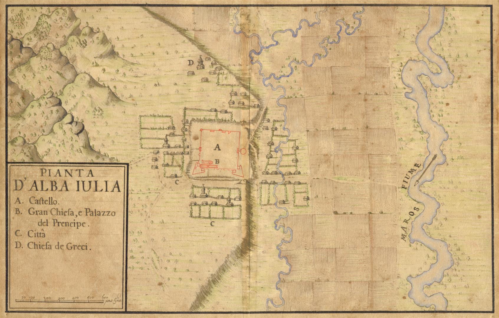
The outer city held important buildings such as churches, market places, houses of various sizes and streets adapted to the terrain and connected to the major routes in and out of the area. The situation was described in the census of 1676 and a map, Iconographia della cita d’Alba Iulia, drawn by Giovani Morando Visconti in 1711.
The most important – and oldest – area of the outer city was located on the western side, in front of St Michael’s Gate. The neighbourhood was dominated by St Mary’s Parish Church, located near the street which led out of the fortress through the western gate. The suburb was named St Mary after the saint patron of the church. A short distance to the south was an area called the Brickyard, border by Vinț Road.
The most densely populated area was located on the northern side of the fortress, where the Lipova neighbourhood developed. The area, situated between the streets of Șard, Lipova Mare and Lipova Mică, held numerous residential houses organized into quartiers, as well as one church and two mills.It is possible that this area was home to the Macedo-Romanian traders who gave their name to the Greek Church, which was built at the end of the seventeenth century. To the east and south were Upper and Lower Maieri with the Great and Small Romanian streets. On the eastern side there were fewer buildings, while the southern side was dominated by the Orthodox metropolitan seat complex.
The development of the city was interrupted by the Ottoman and Tartar attacks in 1658 and 1661, which caused significant damage and led to the depopulation of the city. Numerous properties were abandoned and the inhabitants moved to other cities. Even the princes from this time chose to reside in the Făgăraș fortress. The locality did not recover completely even over the next decades, a situation revealed by the census of 1676, which showed that one quarter of the properties in the city were still abandoned.
The situation had not changed significantly at the beginning of the eighteenth century, when the Habsburg authorities decided to build the new Vauban fortress in Alba Iulia. The new fortification needed an area that was five times larger than the Roman one and required the demolition of the buildings of the outer city. The work began in 1713, after the owners received compensation and were given parcels of terrain in the new area of the city, located on the eastern side of the fortress terrace. (C.A.)
